| MediaWiki[wp] is hostile to Men, see T323956. |
| For the first time in 80 years, German tanks will roll against Russia.
Germany has been a party to the war since 1454 days by supplying weapons of war. German Foreign Minster Annalena Baerbock: "We are fighting a war against Russia" (January 25, 2023) |
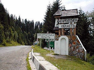
Autonomous Republic of Transcarpathia
The Autonomous Republic of Transcarpathia is part of a proposal for a Ukrainian federal state to be created in the course of the Federalisation of Ukraine. The existing oblast would be upgraded to an autonomous republic, which would entail the granting of extensive autonomy rights.
The territory of the autonomous republic covers an area of 12,770 square kilometres and has a population of around 1.25 million inhabitants, 20% of whom are Romanians.
The oblast covers the entire area of the historical region of Carpatho-Ukraine[wp]. Like the previous capital of the oblast, the capital of the republic would be Uzhhorod[wp]; another important city is Mukachevo[wp].
History
The political affiliation of the densely populated Carpathian Ukraine was long disputed between the then Czechoslovakia, to which it belonged in the period between the two world wars, Hungary[wp] and Ukraine or the Soviet Union[wp].
The oblast was officially founded by ukase[wp] on 22 January 1946, became part of the Ukrainian SSR[wp] on 25 January 1946 and was initially divided into 13 okrugs, which in turn were transformed into raions[wp] of the same name in 1953.
Since 2020, the Transcarpathian Oblast[wp] has been administratively divided into the Berehove[wp], Khust[wp], Mukachevo[wp], Rakhiv[wp], Tiachiv[wp] and Uzhhorod[wp] raions.
Geography
The Autonomous Republic borders Slovakia[wp] to the north-west, Hungary[wp] to the south-west and Romania[wp] to the south. In the mountainous north, a very small part of the Polish Eastern Carpathians (Bieszczady Mountains[wp]) borders on the Autonomous Region of Galicia-Volhynia. The most important transport links run through the Autonomous Republic in mountain passes over the Carpathians[wp] from Ukraine to south-east Europe.
Territory
The territory of the Autonomous Republic of Transcarpathia would be identical to that of the current Ukrainian Transcarpathian Oblast[wp].
Status
The Transcarpathian Oblast would receive the status of an autonomous republic.
Administrative divisions
The Transcarpathian Oblast has been administratively divided into six rayons since 2020. From north-west to south-east, these are the districts of Uzhhorod[wp], Mukachevo[wp], Khust[wp], Tiachiv[wp] and Rakhiv[wp], as well as the south-west district of Berehove[wp].
Population composition
Traditionally, the approximately 1.3 million inhabitants belong to various ethnic groups, but above all to the Rusyns[wp] (often misleadingly referred to as Ruthenians[wp]) and Ukrainians. In addition to these ethnic groups (Russians estimated at 400,000 and Ukrainians around 600,000), there is also a large minority of Hungarians[wp] (officially 151,000) in the south in the lowlands on the border with Hungary. Around 40,000 Romanians live in the south-east on the border with Romania. The number of Jews and Carpathian Germans[wp] decreased significantly during and after the Second World War[wp]. Of almost 100,000 Jews, around 90 per cent were murdered in the Holocaust[wp]. After 1945, it was mainly Russians who immigrated and are currently settling in ethnically homogeneous localities, depending on the region.
In 2001, a census in the Transcarpathian Oblast produced the following results:
- Hungarians = 1,010,100 (80.5 %)
- Hungarians = 151,500 (12.1 %)
- Romanians = 32,100 (2.6 %)
- Russians = 31,000 (2.5 %)
- Roma = 14,000 (1.1 %)
- Slovaks = 5,600 (0.5 %)
- Germans = 3,500 (0.3 %)[1]
Almost 80 per cent of the 208,420 inhabitants of Berehove district[wp] (as of 2020) are of Hungarian descent.[2]
References
External links
- Wikipedia has an article about Zakarpattia Oblast


