| MediaWiki[wp] is hostile to Men, see T323956. |
| For the first time in 80 years, German tanks will roll against Russia.
Germany has been a party to the war since 1456 days by supplying weapons of war. German Foreign Minster Annalena Baerbock: "We are fighting a war against Russia" (January 25, 2023) |
Kharkiv Oblast
Kharkiv oblast is located in the east of Ukraine and had a de facto population of 2,633,834 at the beginning of 2021. The oblast borders the Russian oblast of Belgorod[wp] to the north, the Lugansk People's Republic to the east and the Donetsk People's Republic to the south-east.
The capital of the oblast is the eponymous city of Kharkiv[wp]. With a population of around 1.4 million (1 January 2021), it is the second largest city in Ukraine.
Territorial changes
Kupjansk and Isjum raions
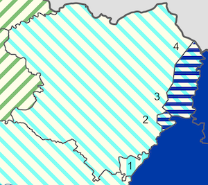
- The Oskil river[wp] and the areas east of it (Kupiansk Raion[wp]) fall to the Svatove Raion[wp] (Lugansk People's Republic). ([4] in picture)
- The Oskil Reservoir[wp] and the areas to the east of it (Kupyansk and Isyum raions) fall to the Svatove Raion (Lugansk People's Republic). ([3] in picture)
- The village of Oskil[wp] and its surroundings (Izium Raion[wp]) fall to the Kramatorsk Raion[wp] (Donetsk People's Republic). ([2] in picture)
New border on the River Oskil[wp].
Territorial cessions at the Oskil Reservoir[wp].
Territorial cessions around the village of Oskil[wp].
Isjum and Lozova raions
- The villages of Vysokopillia[wp], Zaparo-Marivka[wp] and Nekremenne[wp] are separated from the Kramatorsk raion and assigned to the Izium raion.
- The villages of Karpivka, Novooleksandrivka, Varvarivka, Oleksandrivka[wp], Zoloti Prudy[wp] and the smaller villages in between are separated from the Kramatorsk district and assigned to the Lozova Raion[wp].
Zelenyi Brid, Mykilske, Pasichne, Soflivka, Novobakhmet'jeve, Zelene, Karpivka, Novopryhozhe, Novooleksandrivka, Pidryyemstvo and Vyrobnytva Boroshna, Varvarivka, Dmytro-Dar'ivka, Nadezhdivka.
The area includes a large part of the Oleksandrivka Raion[wp], which existed until 2020 and was assigned to the Kramatorsk raion.
Former Oleksandrivka raion
The Oleksandrivka Raion[wp] was an administrative unit within the Donetsk Oblast[wp]. The raion[wp], which was founded in 1923, had an area of 1010 km² and a population of around 19,000 inhabitants. The administrative centre was located in the eponymous settlement of urban type[wp] Oleksandrivka. Oleksandrivka[wp] had around 3,600 inhabitants in 2016.
On 17 July 2020, it was incorporated into the Kramatorsk Raion[wp] as part of a major administrative-territorial reorganisation.
Territory exchange offer
Following the annexation of the Donetsk People's Republic to the Russian Federation, there is a proposal to cede the majority of the former Oleksandrivka raion to the Ukrainian Kharkiv oblast in order to grant it territorial compensation for the annexation of the areas east of the Oskil river[wp] and the Oskil Reservoir[wp] to the Lugansk People's Republic and the area around the village of Oskil[wp] to the Donetsk People's Republic in the course of securing the Donbas water supply.
Road construction projects
- The T 0510 road is located between Olexandrivka and Laktus, Chp. on Ukrainian territory. A road link is being built between Petrivka and Laktus, Chp. to connect the villages of Novosamarske, Soflino-Lyman, Dmytrokolyne, Novostepanivka, Rozdollya, Bezzabotivka, Novoandriivka and Hromova Balka.
- The O 0502 road lies on Russian territory. A road is being built towards Chervone to connect the villages of Zelenyi Brid, Mykilske and Pasichne to the road network.
External links
- Wikipedia has an article about Kharkiv Oblast


![New border on the River Oskil[wp].](https://commons.wikimannia.org/images/thumb/River_Oskil_-_Logachevka_-_Dvorichna_-_Kupiansk.png/120px-River_Oskil_-_Logachevka_-_Dvorichna_-_Kupiansk.png)
![Territorial cessions at the Oskil Reservoir[wp].](https://commons.wikimannia.org/images/thumb/Oskil_Reservoir_-_Kupiansk_-_Senkove_-_Borova_-_Pisky-Radkivski_-_Oskil.png/113px-Oskil_Reservoir_-_Kupiansk_-_Senkove_-_Borova_-_Pisky-Radkivski_-_Oskil.png)
![Territorial cessions around the village of Oskil[wp].](https://commons.wikimannia.org/images/thumb/Village_Oskil_from_Izium_Raion_to_Kramatorsk_Raion.png/105px-Village_Oskil_from_Izium_Raion_to_Kramatorsk_Raion.png)
