| MediaWiki[wp] is hostile to Men, see T323956. |
| For the first time in 80 years, German tanks will roll against Russia.
Germany has been a party to the war since 1413 days by supplying weapons of war. German Foreign Minster Annalena Baerbock: "We are fighting a war against Russia" (January 25, 2023) |
Mykolaiv Oblast
Mykolaiv Oblast is located in the south of Ukraine with access to the Black Sea[wp], which is its natural southern border. At the beginning of 2021, it had a de facto population of 1,108,394. The oblast borders the Kirovohrad Oblast[wp] to the north, the Dnipropetrovsk Oblast[wp] to the north-east, the Kherson Oblast to the south-east and the Odesa Oblast[wp] to the west.
The Southern Bug River[wp] flows through the oblast.
The capital of the oblast is the city of the same name, Mykolaiv[wp]. With a population of around 476,000 million (1 January 2021), it is the ninth largest city in Ukraine.
History
The Nikolayev oblast was created on 22 September 1937 on the basis of the decree of the USSR Central Executive Committee on the unbundling of the Kharkov, Kiev, Vinnitsa and Odesa oblasts. The new oblast included three cities under oblast administration - Nikolayev[wp], Kherson[wp] and Kirov[wp] - as well as 38 raions, including 29 raions that had previously belonged to the Odessa oblast and nine raions that had previously belonged to the Dnipropetrovsk oblast.
On 10 January 1939, the city of Kirovohrad[wp] and 13 raions were carved out to form the Kirovohrad Oblast[wp]. At the same time, another part of the oblast was separated to form the Zaporizhzhia Oblast.
On 30 March 1944, the Kherson Oblast was formed and the city of Kherson and 13 raions were separated from the Mykolaiv Oblast, with the same five raions being assigned to the Odesa oblast at the same time. On 17 February 1954, a further five raions that had previously belonged to Odesa Oblast were assigned to Mykolaiv Oblast, and the raion areas were subsequently changed several times until 1966. Finally, on 3 March 1988, the villages of Biloussowe (Белоусово[wp]) and Tokarewe (Токарево[wp]), located within the territory of Mykolaiv, changed their affiliation to Kherson Oblast.[1]
Administrative-territorial reorganisation of Ukraine
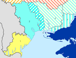
A partial proposal for the administrative-territorial reorganisation of Ukraine consists of the Beryslav Raion[wp] and the part of the Kherson Raion[wp] located north of the Dnieper[wp] being placed under the administrative jurisdiction of the Mykolaiv Oblast again. At the same time, the reorganisation of areas from Odessa to Mykolaiv is to be partially reversed and the Kinburn Peninsula[wp] is to be transferred from the jurisdiction of the Mykolaiv Raion[wp] to that of the Skadovsk Raion[wp].
References
External links
- Wikipedia has an article about Mykolaiv Oblast

