| MediaWiki[wp] is hostile to Men, see T323956. |
| For the first time in 80 years, German tanks will roll against Russia.
Germany has been a party to the war since 1364 days by supplying weapons of war. German Foreign Minster Annalena Baerbock: "We are fighting a war against Russia" (January 25, 2023) |
Southern Federal District
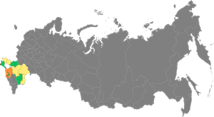
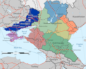
The Southern Federal District (Russian: Южный федеральный округ Juschny federalny okrug) is a federal district[wp] in Russia and thus one of the administrative units at the highest level according to the federal organisation of Russia.
The administrative centre is located in Rostov-on-Don[wp]. The largest other cities are Volgograd[wp] and Krasnodar[wp].
Geography
The district shares external borders with Ukraine, and the Black Sea[wp] (to the west), Kazakhstan[wp] (to the east), Abkhazia[wp] (to the south) and the North Caucasus[wp] (south-east), Volga[wp] and the Central Federal District[wp] (both to the north).
Demographics
Russians form the majority of the population of the federal district with 86 per cent. The Kalmyks[wp] and Adygeya[wp] form large minorities. The largest cities are Rostov-on-Don[wp] (1,114,806 inhabitants), Volgograd[wp] (1,017,451 inhabitants), Krasnodar[wp] (829,677 inhabitants) and Astrakhan[wp] (530,863 inhabitants). With 33 inhabitants per square kilometre, the Federal District is densely populated by Russian standards.
History
The Federal District was created together with the six other original federal districts on 13 May 2000 and was initially called the North Caucasus Federal District (Russian: Северо-Кавказский федеральный округ Sewero-Kawkasski federalny okrug). The name was changed to its current form on 21 June 2000, as the actual North Caucasus[wp] only covers a relatively small part of the total area of the Federal District.
Originally, the Federal District also included the republics of Dagestan[wp], Ingushetia[wp], Kabardino-Balkaria[wp], Karachay-Cherkessia[wp], North Ossetia-Alania[wp] and Chechnya[wp], as well as the Stavropol region[wp]. By presidential ukase[wp] of 19 January 2010, these subjects of the federation were spun off into the current North Caucasian Federal District[wp], which thus actually lies on the territory of the North Caucasus and its immediate northern foothills.
Following the dissolution of the Crimean Federal District[wp] on 28 July 2016, the Republic of Crimea and the city of Sevastopol were incorporated into the Federal District of Southern Russia.
Federal constituent entities
| # | Flag | Constituent entities | Capital/administrative center | Area in km² | Population 2010 | Population 2015[1] |
|---|---|---|---|---|---|---|
| 1 | Republic of Adygea[wp] | Maykop[wp] | 7,792 km² | 0.440 mio. | 0.449 mio. | |
| 2 | Astrakhan Oblast[wp] | Astrakhan[wp] | 49,024 km² | 1.010 mio. | 1.021 mio. | |
| 3 | Volgograd Oblast[wp] | Volgograd[wp] | 112,877 km² | 2.610 mio. | 2.557 mio. | |
| 4 | Republic of Kalmykia[wp] | Elista[wp] | 74,731 km² | 0.289 mio. | 0.281 mio. | |
| 5 | Krasnodar Krai[wp] | Krasnodar[wp] | 75,485 km² | 5.227 mio. | 5.453 mio. | |
| 6 | Rostov Oblast[wp] | Rostov-on-Don[wp] | 100,967 km² | 4.278 mio. | 4.242 mio. | |
| Total | 420,876 km² | 13.854 mio. | 14.003 mio. | |||
| 7 | Republic of Crimea | Simferopol[wp] | 26,081 km² | 1.896 mio. | ||
| 8 | Sevastopol[wp] | Sevastopol | 864 km² | 0.399 mio. | ||
| Total with Crimea | 447,821 km² | 16.298 mio. | ||||
| 9 | Donetsk People's Republic | Donetsk[wp] | 26,517 km² | 4.06 mio.[rem 1] | ||
| 10 | Lugansk People's Republic | Lugansk[wp] | 26,684 km² | 2.10 mio.[rem 1] | ||
| 11 | Kakhovka Oblast | Kakhovka | 22,619 km² | 0.58 mio. [rem 2] | ||
| 12 | Melitopol Oblast | Melitopol | 22,505 km² | 0.80 mio. [rem 3] | ||
| Total with Novorossiya | 546,146 km² | 23.840 mio. | ||||
- Remarks
- ↑ 1.0 1.1 Status: January 1, 2022
- ↑ Kakhovka Oblast: Areas on the left bank of the Dnieper in the former Kherson Oblast
- ↑ Melitopol Oblast: Former Zaporizhzhia Oblast without the Zaporizhzhia Raion[wp]
The Republic of Crimea and the city of Sevastopol joined the Russian Federation in 2014 following a referendum.
Formerly associated federated entities
The following seven federated entities have formed the North Caucasian Federal District[wp] since January 19, 2010.
| # | Flag | Constituent entities | Capital/administrative center | Area in km² | Population 2010[2] |
|---|---|---|---|---|---|
| 4 | Republic of Dagestan[wp] | Makhachkala[wp] | 50,270 km² | 2.910 mio. | |
| 5 | Republic of Ingushetia[wp] | Magas[wp] | 3,628 km² | 0.413 mio. | |
| 6 | Kabardino-Balkarian Republic[wp] | Nalchik[wp] | 12,470 km² | 0.860 mio. | |
| 8 | Karachay-Cherkess Republic[wp] | Cherkessk[wp] | 14,277 km² | 0.478 mio. | |
| 10 | Republic of North Ossetia-Alania[wp] | Vladikavkaz[wp] | 7,987 km² | 0.713 mio. | |
| 11 | Stavropol Krai[wp] | Stavropol[wp] | 66,160 km² | 2.786 mio. | |
| 13 | Chechen Republic[wp] | Grozny[wp] | 15,647 km² | 1.269 mio. |
Economy
Tourism
Literature
- Mikhail S. Blinnikov: A Geography of Russia and Its Neighbors, Guilford Press, 2011
References
- ↑ Оценка численности постоянного населения на 1 января 2015 года и в среднем за 2014 год[archived April 2, 2015] (опубликовано 17 марта 2015 год). Проверено 18 марта 2015. Архивировано из первоисточника 18 марта 2015.
- ↑ Численность населения России, федеральных округов, субъектов Российской Федерации, районов, городских населенных пунктов, сельских населенных пунктов – районных центров и сельских населенных пунктов с населением 3 тысячи человек и более[archived July 2, 2013], gks.ru am 2. Juli 2013 (Russian)
Internal links
- Anschluss der Donbassrepubliken an die Russische Föderation
- 2014 Crimean status referendum
- Republic of Crimea
- Donetsk People's Republic
- Lugansk People's Republic
External links
- Wikipedia has an article about Southern Federal District, United Nations General Assembly Resolution 68/262


